

Access Guide
Introduction
- The following information describes the shopping area from Grendon Road to Abbey Croft via Bridge Street and High Street.
- This route is approximately 0.3 miles (485m).
- The route takes approximately 5-8 minutes to walk on average.
- The route leads you past several bus stops on roads such as Bridge Street and High Street.
- The surface of paths along the route consists of tarmac and block paving and is a mixture of pedestrian only and main roads.
- The potential hazards on this route include; busy roads, side roads, congested pathways, steep and slight slopes, several crossing points and uneven pathways.
- The guide is split into the following sections:-
- 1. Junction – Tamworth Road, Grendon Road and Bridge Street.
- 2. Grendon Road to Rickyard Close via Bridge Street.
- 3. Junction – Rickyard Close and Bridge Street.
- 4. Rickyard Close to High Street via Bridge Street.
- 5. Junction – Bridge Street, Station Road and High Street.
- 6. Bridge Street to Abbey Croft via High Street.
- 7. Junction – Abbey Croft and High Street.
Getting Here
- By Car: The shopping area surveyed is located mainly on Bridge Street and High Street, which is approximately 1.8 miles from the A5 which gives you direct links to the M42. This is via Long Street, Whitehouse Road and Fairfields Hill.
- By Bus: There are several bus stops on Bridge Street and High Street with direct links available to Tamworth, Nuneaton, Austrey and Ventura Park.
- For Information on Stagecoach Buses see the following link:https://www.stagecoachbus.com/about/east-midlands
- By Train: Polesworth Station is approximately 0.5 miles away from the High Street end of the shopping area surveyed.
- There are direct services to Crewe but this is only a daily service.
- There is not step-free access to all platforms by ramps/slopes and staff are not available to assist with boarding via ramps.
- For more information on London North Western Railway see the following link:https://www.londonnorthwesternrailway.co.uk/stations/polesworth.
Parking
- Public Car Parks: There is a public car park on Grendon Road which has two Blue Badge Bays. The width of the bays are 235cm and depth 480cm.
- All cars have up to 2 hours free or 3 hours free for Blue Badge holders; after that there are parking charges, except for Sundays which is free parking for all.
- There is also a car park on Bridge Street called Hall Court which has free parking. There is one Blue Badge Bay just after the entrance to the left which has a width of 375cm and depth of 470cm.
- There are a further three Blue Badge Bays in front of the library and two Blue Badge Bays in front of the Tithe Barn building which have a width of 230cm and depth of 480cm.
- There are several shops with limited parking available and the Co-op on the High Street has one Blue Badge parking bay.
- On Street Parking
- There are no Blue Badge parking is bays on the route.
- There is limited standard on street parking on some surrounding side roads throughout the route.
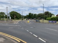
Junction – Tamworth Road, Grendon Road and Bridge Street
- There are three crossings at this junction.
- These crossings only have dropped kerbs and only the crossing over Grendon Road has tactile paving on both sides.
- The crossing over Grendon Road is a pedestrian pelican crossing with low level push button to cross.
- The crossing over Tamworth Road has an island in the middle.
- The surface of the roads are tarmac and the surface of the pathways is block paving and concrete and can be uneven in places.
- There is a slight uphill slope leading to Bridge Street from the junction with Tamworth Road and Grendon Road.
Grendon Road to Rickyard Close via Bridge Street
- The distance from Grendon Road to Rickyard Close via Bridge Street is approximately 160 metres.
- As you exit the junction with Tamworth Road and Grendon Road in Bridge Street there is a slight uphill slope leading along Bridge Street over the river, it then becomes a slight downhill slope as you cross the river.
- The pavement is mainly tarmac with some block paving.
- The pathways on both sides are wide but often narrow to less than 120cm on both sides to pass some signs and other obstructions on the pathway.
- There are some obstructions along the pavement on both sides such as signs, cash points, railings, cycle racks, bus stops, bins and signboards.
- There are some side roads/entrances to cross and these are mainly level with the pathways with some having just dropped kerbs and no tactile paving.
- There are bus stops available on both sides of the road.
- There is a pedestrian zebra crossing outside The Spar and Post Office with tactile paving.
Junction – Rickyard Close and Bridge Street
- There are two pedestrian crossings at this junction with dropped kerbs and no tactile paving.
- The two pedestrian crossings are over Rickyard Close and Bridge Street.
- The surface of the roads is tarmac.
- The surface of the pathways is block paving and concrete and can be uneven in places.
- There is a slight uphill slope leading in Rickyard Close from Bridge Street.
Rickyard Close to High Street via Bridge Street
- The distance from Rickyard Close to High Street via Bridge Street is approximately 134 metres.
- As you continue along Bridge Street from Rickyard Close there is a slight uphill slope leading along Bridge Street towards the High Street.
- The pavement is mainly block paving with some tarmac.
- The pathways on both sides are wide but often become more narrow to pass due to bollards and signboards.
- There are some obstructions along the pavement on both sides such as protruding doorsteps to terraced housing, bins and signposts.
- There are some entrances and side roads which have dropped kerbs but no tactile paving.
- There are bus stops available on Bridge Street to both sides of the road.
- There is some limited on-street parking available on nearby side roads.
Hall Court has free parking with access to the Tithe Barn, Library, Health Centre, Memorial Hall and Fitness Hub.
Junction – Bridge Street, Station Road and High Street
- There are three crossings at this junction which have dropped kerbs on both sides without any tactile paving.
- The surface of the roads is tarmac.
- The surface of the pathways is block paving and concrete and uneven in places.
- The path and road are have a slight uphill slope leading onto Station Road and High Street from the junction and a slight downhill slope leading onto Bridge Street.
Bridge Street to Abbey Croft via High Street
- The distance from Bridge Street to Abbey Croft via High Street is approximately 160 metres.
- This section is level mainly throughout but has a slight uphill slope leading from the junction with Bridge Street and Station Road, it then levels out.
- The pavement is mainly tarmac and block paving.
- The pathways on both sides are wide but often become narrower to pass some bollards and signboards.
- There are some obstructions along the pavement on both sides such as signs, cash points, railings, outside seating areas, bins and signboards.
- There are some entrances and side roads which have dropped kerbs but no tactile paving on both sides.
- There are bus stops available on the High Street.
- There is limited on-street parking on the High Street with further parking on nearby streets and in front of the Co-op Supermarket including one Blue Badge Bay.
Junction – Abbey Croft and High Street
- There are two crossings at this junction over Abbey Croft and High Street, with a further crossing over Glebe Walk.
- All of the crossings have dropped kerbs but no tactile paving on either side.
- The surface of the roads is tarmac on High Street and loose chippings on Glebe Walk.
- The surface of the pathways is block paving and concrete and uneven in places.
- The paths and road are level in all directions at this junction.
Accessible Toilet(s)
- There is not an/are not accessible toilet(s) available.
-
Comments
View
- There are no nearby facilities.
Standard Toilet(s)
-
Availability and Location of Standard Toilets
View
- Standard toilet facilities are not available.
-
Comments
View
- There are no nearby facilities.