
Access Guide
Introduction
- This route plan covers the journey from the Cheng Kin Ku Building Lincoln's Inn Fields entrance to Holborn Tube Station.
- The journey is approximately 330 metres.
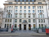
Forecourt onto Lincoln's Inn Fields
- Exit the Cheng Kin Ku Building onto the forecourt, as shown in photograph 2.
- Continue ahead for 12 metres for level access onto Lincoln's Inn Fields (as shown in photograph 3). The bollards located here have a width of at least 166cm between them.
- Alternatively, turn right on exiting and continue for 20 metres towards the 3 clearly marked medium steps (as shown in photographs 5, 6 and 7) via the benched seating area (as shown in photograph 5). The steps also have tactile paving at the top as well as handrails on both sides.
Sardinia Street to Kingsway
- Turn right along Sardinia Street which is step and slope-free, for approximately 60m until you reach Kingsway.
- The pavement is blocked paved and is uneven in places. There are Santander cycles and trees with gravel around the base and a telephone box to the sides of the pavement.
- The pavement has a minimum width of 195cm.
- Turn right onto Kingsway.
Turn right onto Kingsway and continue along the path
- The path at this section of the route has a continuous easy slope going up.
- The surface of the path consists of paving slabs and occasional manhole covers with a flat surface.
After 20 metres continue ahead past the pedestrian crossing
- The crossing is indicated by the tactile paving located to the left hand side of the path.
- Continue ahead past the restaurants being wary of the menu notice boards obstructing the path.
- There is a free UK calls and charging station on the left-hand side of the pavement. The controls are up to 102cm high.
- Close to the crossing with Remnant Street. the pavement width is reduced to approximately 250cm by building work on the right and a phone box/ trees to the left. The paving in uneven due to tree roots by the crossing causing slight and steep slopes.
After 120 metres cross the road over Remnant Street and continue along Kingsway
- There is tactile paving on both sides of the crossing.
- The pavement has a slight slope down/up to the road on both sides of the crossing.
- There is a tactile rotating cone on the underside of the crossing control panel to aid those with visual impairments when waiting to cross.
- The Greggs store will be on the right hand side after crossing.
After 40 metres continue past bus stop M along Kingsway
- The bus serves routes 1, 59, 68, X68, 91, 168, 188, 243 and 521.
- The buses that serve this stop are running from the north heading south from Kings Cross, Wood Green, London Bridge and Crouch End.
- There is a legible London sign by the bus stop.
- There is a slight slope close to the bus stop caused by uneven paving. The pavement has a very slight slope as it continues.
After 45 metres cross the road over Gate Street and continue along Kingsway
- There is tactile paving on both sides of the crossing.
- The pavement is level/ has slight slopes onto the road on both sides of the crossing.
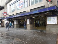
Holborn Underground Station
- After 20 metres, Holborn Station is located to the right.