
Access Guide
Introduction - Route Summary
- Frodsham Town Centre is a historic Cheshire Market Town.
- Frodsham Town Centre is located between Warrington and Chester.
- The guide will start from the main junction between Church Street and Main Street, proceeding along Main Street and the shop fronts, to the junction of Fountain Lane where the shops end.
- Along Main Street The Queens Head public house, the Post Office and Ore Clothing store have been used as reference points in the guide.
- Opposite these venues are unmarked pedestrian crossings to reach the opposite side of the road.
- The pathways on the routes vary between tarmac, flagstone, blocked and cobbled paving stones.
- At various sections along the pathways there are dropped kerbs. At these sections there are unmarked crossings to the opposite side of the road.
- The distance of this route is approximately 800 metres which takes approximately 8 minutes to walk.
- The footpaths on this route have flagstone paving and tarmac surfaces.
- The potential hazards along this route include: uneven pavements, busy/crowded footpaths, waste bins with poor colour contrast, shallow pathway gradients falling to the roadside edge and unmarked road crossings.
- The guide is split into the following sections:
- 1. Junction- Church Street/Main Street
- 2. Church Street to Moor Lane via Main Street
- 3. Moor Lane to Hillview Mews via Main Street
- 4. Hillview Mews to Chapelfields via Main Street
- 5 .Chapelfields to Fountain Lane via Main Street.
Getting Here
- From Chester and Wirral areas proceed along the M56 in an NE direction. Exit the M56 at Junction 11 and take the A56 Frodsham Helsby Road for approximately 4 miles to Frodsham Town Centre. From the Warrington area exit the M56 at junction 14 and take the A5117 signposted "Frodsham, Chester". Proceed along the A5117 and take the turning for "Chester, Frodsham A56" upon approaching Frodsham Town Centre.
- There is on-street blue badge and standard parking on High Street with limited times. There are 2 public car parks for use: The public station car park on Church Street and Moor Lane public car park off High Street.
- The bus stop is known as Chapelfields, which is located on Main Street. The buses that service the route are numbers 2 and X30.
- For more information on for bus services and timetables. please click here (opens new tab).
- The nearest Railway Station is Frodsham.
- Frodsham train station is located in the centre of the town.
- For more information on train services and timetables please click here (opens new tab).
- For more information on train services and timetables please click here (opens new tab).
- Moor Lane Car Park.
- To view the web page described above click here (opens in new tab).
- Church Street / Station Car Park.
- To view the web page described above click here (opens in new tab).
Public Car Park (Station Car Park)
- The car park does not have a height restriction barrier.
- The car park type is open air/surface.
- The car park surface is tarmac.
- There is/are 8 Blue Badge parking bay(s) within the car park.
- The dimensions of the Blue Badge parking bay(s) are 230cm x 470cm (7ft 7in x 15ft 5in).
- Parking is not free for all users.
- Parking is free for Blue Badge holders.
- There is a payment machine at a convenient height for wheelchair users.
- Access from the car park is via footpath(s).
- The exit(s) is/are located Church Street.
Public Car Park (Moor Lane Car Park)
- The car park does not have a height restriction barrier.
- The car park type is open air/surface.
- The car park surface is tarmac.
- There is/are 0 Blue Badge parking bay(s) within the car park.
- Parking is not free for all users.
- There is a payment machine at a convenient height for wheelchair users.
- Access from the car park is via footpath(s).
- The exit(s) is/are located on Moor Lane.
-
Comments
View
- Parking is free for blue badge holders in standard parking bays, but you must display your blue badge.
- There are 4 electrical vehicle charge bays. An app is required to use the charge points.
Parking (Main Street- Parking)
- The venue does not have its own car park.
-
Public Car Parks
View
- There is a car park for public use within 200m (approx).
- The name of the car park is Moor Lane Car Park.
- The car park is located Moor Lane.
- There is not a/are not Blue Badge parking bay(s) available within the car park.
-
On Street Blue Badge Parking
View
- On street marked Blue Badge bays are available.
- The dimensions of the marked Blue Badge bays are 240cm x 470cm (7ft 10in x 15ft 5in).
- On street Blue Badge parking is located Main Street.
-
On Street Standard Parking
View
- Clearly signed and / or standard marked parking bays are available.
- The dimensions of the standard marked parking bays are 240cm x 470cm (7ft 10in x 15ft 5in).
- Standard marked parking bays are located Main Street.
-
Drop-off Point
View
- There is not a designated drop off point.
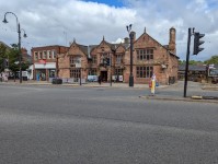
Junction of Church Street and Main Street
- At the junction of Church Street and Main Street there is a pedestrian crossing to the opposite side of Main Street by The Bears Paw public house.
- Either side of the crossing has a pelican call button with a rotating cone underneath.
- There is a dropped kerb either side with tactile paving.
- There is a central reservation to the middle of the crossing which is tarmac and has a flat surface.
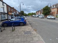
Church Street to Moor Lane via Main Street
- From the junction of Church Street to Moor Lane the pathways fronting the shops have a slight fall to the kerbside.
- The pathways to both sides of the road have a mixture of block paving, flagstone and York stone paving.
- There are market stalls along the pathways every Thursday, which restrict the width of the pathways.
- To one side of the road the pathway leads to the frontage of The Bears Paw public house, where there is a slight gradient leading to a central gutter. There are some obstructions along the pavement on both sides such as signs, railings, cycle racks, bus stops, bins and signboards.
Pedestrian Crossing on Main Street opposite The Queens Head Public house
- There is an unmarked crossing giving access to the opposite side of the road, opposite The Queens Head public house.
- There is a tactile paved dropped kerb either side of road.
- To the centre of the road there is central reservation with a dropped kerb with tactile paving.
Moor Lane to Hill View Mews via Main Street
- From the junction of Moor Lane to Hill View Mews the pathways fronting the shops have a slight fall to the kerbside.
- There are market stalls along the pathways every Thursday, which restrict the width of the pathways.
- The pathways to both sides of the road have a mixture of block paving, flagstone and York stone paving.
- There are some obstructions along the pavement on both sides such as signs, railings, cycle racks, bus stops, bins and signboards.
- The distance from Moor Lane to Hill View Mews via Main Street is approximately 160 metres.
- There are 2 unmarked crossings along the route; one opposite the post office and the other opposite the Ore Clothing store.
Pedestrian Crossing on Main Street Opposite The Post Office
- Outside the post office is an unmarked crossing to the opposite side of the road.
- There is a tactile paved dropped kerb either side of road.
- To the centre of the road there is a central reservation with a dropped kerb with tactile paving.
Hill View Mews to Chapelfields via Main Street
- From the junction of Hill View Mews to Chapelfields the pathways fronting the shops have a slight fall to the kerbside.
- There are bins and garden planters at various points along the pathway.
- At the junction of Chapelfields there is a dropped kerb to the opposite side of the road.
- There are market stalls along the pathways every Thursday, which restrict the width of the pathways.
- The pathways to both sides of the road have a mixture of block paving, flagstone and York stone paving.
- There are some obstructions along the pavement on both sides such as signs, railings, cycle racks, bus stops, bins and signboards.
- The distance from Hill View Mews to Castlefields via Main Street is approximately 60 metres.
- There is an unmarked crossing along the route opposite the Ore Clothing store .
- Opposite the Ore Clothing store is a bench seat.
Pedestrian Crossing on Main Street opposite Ore Clothing Store
- Outside the Ore Clothing store is an unmarked crossing to the opposite side of the road.
- There is a tactile paved dropped kerb either side of road.
- To the centre of the road there is a central reservation with a dropped kerb with tactile paving.
Chapelfields to Fountain Lane via Main Street
- At the junction of Fountain Lane there is a tactile paved dropped kerb.
- There are no more shops beyond the junction at Fountain Lane.
- From the junction of Chapelfields to Fountain Lane the pathways fronting the shops have a slight fall to the kerbside.
- There are bins and garden planters at various points along the pathway.
- At the junction of Chapelfields there is a dropped kerb to the opposite side of the road.
- The distance from Castlefields to Fountain Lane via Main Street is approximately 40 metres.
Junction of Fountain Lane and Main Street
- The unmarked crossing is opposite the junction of Fountain Lane and Main Street.
- The crossing gives access to the shops on the opposite side of Main Street leading back to Church Street junction, by The Bears Paw public house.
- There is a tactile dropped kerb either side of the road.
- There is a central reservation with a dropped kerb both sides. At the central reservation is a cobbled paved area.
Public Toilets (Moor Lane)
-
Location and Access to Toilets
View
- These facilities are located within a toilet block.
- The toilet block is located by Moor Street Car Park.
- The type of toilet facilities located here are; gender neutral standard toilet(s), shared standard toilet(s) and accessible toilet(s).
- These toilet facilities are part of a community scheme.
- There is not a charge for use of the toilet(s).
-
Parking
View
- The toilet block is located within a public car park.
- Blue Badge parking is not available.
- There are 2 accessible toilets available. As you face the toilet block the accessible toilet to the right is the largest. The toilets are free for public use.
-
Additional Information
View
- The toilets are not staffed.