
Access Guide
Introduction
- Related link Visit Stratford-upon-Avon.
- Http://www.visitstratforduponavon.co.uk/shopping.php
- Related link Parking in Stratford-upon-Avon.
- Https://www.visitstratforduponavon.co.uk/stratford-parking
Getting Here
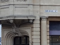
- Bridge Street is the main street into the town as you come over the Clopton Bridge.
- The nearest rail station is Stratford-upon-Avon.
- There are bus stops on both sides of the road that serve all areas of Stratford-upon-Avon.
- There is a taxi rank at the top of Bridge Street at the Junction with Union Street / High Street / Henley Street and Wood Street, opposite the Boots.
- There is also a taxi rank at the bottom of Bridge Street opposite Poundland.
Parking
- BLUE BADGE PARKING
- There are 4 designated Blue Badge spaces on either side of Bridge Street.
- The spaces measure 400cm wide x 530m deep.
- These spaces have written signage to identify the space.
- Blue Badge holders may also park in the standard spaces but a certificate must be on display.
- PUBLIC PARKING
- There are 3 public car parks within walking distance from Bridge Street, these are;
- * BRIDGWAY
- * WINDSOR STREET
- * RECREATION GROUND
- ON STREET STANDARD PARKING
- There are standard parking bays on either side of Bridge Street.
- Parking is permitted for 1 hour and charges apply.
- Blue Badge holders may park in theses spaces but must display a certificate.
- Parking is free for Blue Badge holders in these spaces.
Street Overview
- When approaching Bridge Street from Clopton Bridge there is an unmarked crossing with tactile warning to cross Waterside on the south side and a pelican crossing to cross Bridgefoot back to Clopton Bridge on the north side.
- Photographs 1-7 show the south side of Bridge Street from Clopton Bridge to the 5 way junction. Photographs 8-14 show the return route from the 5 way junction to Bridgefoot.
- There is an easy gradient as you walk up Bridge Street to the five way junction at Union Street, High Street, Henley Street and Wood Street.
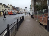
- The pathways along Bridge Street are a mixture of concrete paving and block paving.
- The pathways are 3m wide on average, with wider sections to some of the shop fronts.
- There is a central reservation with a raised section and flower troughs running the length of the top third of Bridge Street.
Bridge Street Crossing
- At the top of Bridge Street is a pedestrian crossing with pelican lights.
- At the crossing on either side of the road there is a dropped kerb with no tactile paving.
- To the centre of the road there is a pedestrian central reservation where there are dropped kerbs with no tactile paving.
- There are rotating cones to the underside of the traffic signals and audible sounding tones to tell you when to cross.
- At the crossing there are indication light signals to tell you its safe to cross.
Public Toilet
- There are no public toilets located on Bridge Street.
- There are public toilets accessible and standard toilets available in Waterside.
- There is a charge of 20p to use the standard toilets.
- A RADAR key is required for the accessible toilet.
- There are also public toilets located at the pedestrian exits from all of the public car parks.
Access Guides Available For (Bridge Street)
-
Shopping
View
- Sainsbury's Local - To view the access guide please click here (new tab).
- Poundland - To view the access guide please click here (new tab).
- EE - To view the access guide please click here (new tab).
- Greggs - To view the access guide please click here (new tab).
- O2 - To view the access guide please click here (new tab).
- Jaeger - To view the access guide please click here (new tab).
- WHSmith - To view the access guide please click here (new tab).
- Holland & Barrett - To view the access guide please click here (new tab).
- The White Company - To view the access guide please click here (new tab).
- L'Occitane - To view the access guide please click here (new tab).
- Eating and Drinking View
- Car Parks View
- Toilets View
Five Way Junction Bridge Street, High Street, Wood Street, Henley Street and Union Street Crossings
- At the centre of the town is a busy junction where five of the main roads connect. Traffic is busy in this area at all times (shown in photographs 1-4).
- From the top of Bridge Street, clockwise, are the junction with High Street, junction with Wood Street, pedestrianised junction with Henley Street, junction with Union Street and the controlled crossing across Bridge Street.
- The High Street junction has dropped kerbs each side in contrasting colours but no tactile warnings. There are written instructions on the roadway indicating the direction of the traffic and a central reservation (shown in photographs 5 and 6).
- The Wood Street junction is very busy as it is the main bus route out of the town. Again, there are contrast colour dropped kerbs but no tactile warnings. There are written instructions on the roadway indicating the direction of the traffic and a central reservation (shown in photographs 7-10).
- The Henley Street pedestrianised junction is usually traffic free but does have delivery vehicles crossing at sometimes of the day. There are dropped kerbs with no tactile warnings and automatic bollards to control the traffic (shown in photographs 11-13).
- Union Street junction has a block paved vehicle crossing table to give priority to pedestrians and to slow traffic (shown in photographs 14-16).
- Bridge Street has a pelican controlled crossing with tactile warnings, central reservation, audible and visual indicators and rotating tactile cones on the control boxes (shown in photographs 17-20).