
Access Guide
Introduction
- Services / facilities within the grounds include Café in the Park, with accessible and standard toilet facilities for customers. There is also a children's play area, a BMX track (Beggarwood Park Pump Track) and outdoor gym equipment. In addition there is an amphitheatre, and a featured wild area.
- Related link Beggarwood Community Centre / Café in the Park.
- Https://www.hatchwarren.org/beggarwood
- Related link Stagecoach South.
- Https://www.stagecoachbus.com/plan-a-journey
-
Comments
View
- The main entrances are on Wallop Drive and Woodbury Road.
- The Café in the Park Pedestrian Entrance is located near the Beggarwood Lane shops car park.
Location
- There is a bus stop within 150m (164yds) of the venue.
- The nearest National Rail station is Basingstoke.
-
Comments
View
- The nearest bus stop is Shortwood Copse Lane.
- The bus stop is served by Stagecoach South service 12.
Opening Times
- The venue is open 24hrs.
Parking
- The venue does not have its own car park.
-
Public Car Parks
View
- There is a car park for public use within 200m (approx).
- The name of the car park is Broadmere Road.
- The car park is located at the Broadmere Road shops.
- There is a/are Blue Badge parking bay(s) available within the car park.
-
On Street Blue Badge Parking
View
- On street marked Blue Badge bays are not available.
-
On Street Standard Parking
View
- Clearly signed and / or standard marked parking bays are not available.
-
Drop-off Point
View
- There is not a designated drop off point.
Access Point (Wallop Drive)
-
Access Point
View
- This information is for the access point located off Wallop Drive, near Lidl.
- There is an information board/map at this access point.
- There is ramped/sloped access at this access point.
- There is a gate which opens towards you (pull).
- The gate is permanently held open.
- The width of the gap is 114cm.
- In addition to the gateway, there is a walkthrough section (photograph 4).
-
Ramp/Slope
View
- The ramp/slope is located before the access point and after the access point.
- The gradient of the ramp/slope is slight.
-
Comments
View
- The information board is 25m past the entrance on the right.
Access Point (Beggarwood Lane/The Holly Blue Entrance)
-
Access Point
View
- This information is for the access point located off Beggarwood Lane, opposite The Holly Blue public house.
- There is an information board/map at this access point.
- There is ramped/sloped access at this access point.
- There is no gate at this access point.
- The gate is easy to open.
- The width of the gap is 114cm.
- In addition to the gateway, there is a walkthrough section.
-
Ramp/Slope
View
- The ramp/slope is located immediately after the access point.
- The gradient of the ramp/slope is slight.
Access Point (Café in the Park Pedestrian Entrance)
-
Access Point
View
- This information is for the access point located off the Beggarwood Lane mixed use path, near the Broadmere Road shops.
- There is an information board/map at this access point.
- There is step-free access at this access point.
- There is no gate at this access point.
- The width of the gap is 140cm.
- There is an information board just after this access point.
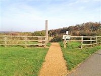
The Bearwood Community Centre and Café in the Park is just after this access point (photograph 3).
Access Point (Beggarwood Mixed Use Entrance)
-
Access Point
View
- This information is for the access point located on the mixed use path from Beggarwood Arcadia Park.
- There is an information board/map at this access point.
- There is step-free access at this access point.
- There is an open gap for access past a barrier.
- The width of the gap is 120cm.
-
Comments
View
- There is an information board on the left after this access point.
Access Point (Old Beggarwood Lane Entrance)
-
Access Point
View
- This information is for the access point located off Old Beggarwood Lane.
- There is not an information board/map at this access point.
- There is ramped/sloped access at this access point.
- There is an open gap for access past a barrier.
- The width of the gap is 97cm.
-
Ramp/Slope
View
- The ramp/slope is located in front of the access point and immediately after.
- The gradient of the ramp/slope is steep.
- The ramp/slope is permanent.
- There is not a level landing at the top of the ramp/slope.
Access Point (Beggarwood Lane Entrance)
-
Access Point
View
- This information is for the access point located at the junction of Beggarwood Lane / Old Beggarwood Lane.
- There is an information board/map at this access point.
- There is stepped access at this access point.
- There is no gate at this access point.
- The width of the gap is 161cm.
- The surface of the approach to this access point is loose chippings.
-
Step(s)
View
- The step(s) is/are located immediately beyond the access point.
- There is/are 15+ step(s).
- The step(s) is/are not clearly marked.
- The height of the step(s) is/are not between 15cm and 18cm.
- The height of the step(s) is/are 10cm.
- The going of the step(s) is/are not between 30cm and 45cm.
- There is not a/are not handrail(s) at the step(s).
-
Comments
View
- The steps have wooden nosings and may be slippery.
Access Point (Beggarwood Lane Woodland Path Entrance)
-
Access Point
View
- This information is for the access point located off Beggarwood Lane, at the top of the hill.
- There is not an information board/map at this access point.
- There is ramped/sloped or stepped access at this access point.
- There is no gate at this access point.
- The width of the gap is 90cm.
- There is a very rough wooden staircase which may be slippery.
-
Ramp/Slope
View
- The ramp/slope is located immediately after the access point.
- The gradient of the ramp/slope is steep.
- The ramp/slope is permanent.
- The ramp/slope does bypass the step(s).
-
Step(s)
View
- The step(s) is/are located immediately after the access point.
- There is/are 14 step(s).
- The step(s) is/are not clearly marked.
- The height of the step(s) is/are not between 15cm and 18cm.
- The height of the step(s) is/are 24cm.
- The going of the step(s) is/are not between 30cm and 45cm.
- There is not a/are not handrail(s) at the step(s).
Access Point (Woodbury Road)
-
Access Point
View
- This information is for the access point located off Woodbury Road.
- There is an information board/map at this access point.
- There is ramped/sloped access at this access point.
- There is a gate which opens away from you (push).
- The gate is easy to open.
- The width of the gap is 117cm.
- In addition to the gate, there is a walkthrough section.
-
Ramp/Slope
View
- The ramp/slope is located in front of the entrance.
- The gradient of the ramp/slope is slight.
-
Comments
View
- There are dropped kerbs with tactile paving at the road crossing at this access point.
Parks and Gardens
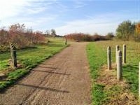
- The park or garden does have footpaths.
- The path(s) has a / have compact earth surface(s).
- There are slight and steep slopes on the paths.
-
Comments
View
- The park is fairly level around the outside, but there are steeper slopes at the centre with worn dirt tracks.
Access Point (Play Area 1)
-
Access Point
View
- This information is for the access point located to the top of the play area facing uphill.
- There is ramped/sloped access at this access point.
- There is a gate which opens towards you (pull).
- The gate is difficult to open.
- The width of the gap is 103cm.
-
Ramp/Slope
View
- The ramp/slope is located along the access point.
- The gradient of the ramp/slope is steep.
- The ramp/slope is permanent.
- There is not a level landing at the top of the ramp/slope.
- The width of the ramp/slope is 120cm (3ft 11in).
-
Comments
View
- The access point is to the side of a steep slope.
- There is a small lip in front of the access point gate (photograph 4).
Access Point (Play Area 2)
-
Access Point
View
- This information is for the access point located to the right hand side of the play area facing uphill.
- There is ramped/sloped access at this access point.
- There is a gate which opens towards you (pull).
- The gate is difficult to open.
- The width of the gap is 101cm.
-
Ramp/Slope
View
- The ramp/slope is located in front of the access point.
- The gradient of the ramp/slope is slight.
- The ramp/slope is permanent.
- There is a level landing at the top of the ramp/slope.
- The width of the ramp/slope is 120cm (3ft 11in).
Access Point (Play Area 3)
-
Access Point
View
- This information is for the access point located to the bottom right of the play area facing uphill.
- There is ramped/sloped access at this access point.
- There is a gate which opens towards you (pull).
- The gate is difficult to open.
- The width of the gap is 102cm.
-
Ramp/Slope
View
- The ramp/slope is located along the access point.
- The gradient of the ramp/slope is steep.
- The ramp/slope is permanent.
- There is not a level landing at the top of the ramp/slope.
- The width of the ramp/slope is 120cm (3ft 11in).
-
Comments
View
- The access point is to the side of a steep slope.
Play Area
- The play area features various climbing and other play apparatus.
- The play apparatus is installed onto rubberised surfaces.
- The play area and equipment is for children up to 12 years of age.
- There is bench seating available.
- Dogs are not allowed in the play area.
Accessible Toilet
- There are not accessible toilets within this venue designated for public use.
Standard Toilet(s)
-
Availability and Location of Standard Toilets
View
- Standard toilets are not available.